Showing 10 items matching sandy bay
-
 Phillip Island and District Historical Society Inc.
Book, CUTHBERTSON, Bern, In the wake of Bass and Flinders : 200 years on : the story of the re-enactment voyages 200 years on in the whaleboat Elizabeth and the replica sloop Norfolk to celebrate the bicentenary of the voyages of George Bass and Matthew Flinders, 2001
... Sandy Bay, Tasmania ...Stamped 'Phillip Island & District Historical Society'. Signed by the author.george bass, journeys, australia, bern cuthbertson, matthew flinders, elizabeth, boat, norfolk, ship, historical reenactments, explorers, 18th century, discovery, exploration -
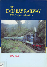 Victorian Railway History Library
Book, Lou Rae, The Emu Bay Railway VDL Company to Pasminco, 1997
... Sandy Bay, Tasmania, Australia ...The history of the Emu Bay Railway Company in Tasmania from the Van Diemen's Land Company to the Pasminco company years.Index, bib, ill, maps, p.270.non-fictionThe history of the Emu Bay Railway Company in Tasmania from the Van Diemen's Land Company to the Pasminco company years.emu bay railway company., mineral industries -- tasmania -
 Federation University Historical Collection
Document, Ken Clements, Peterborough Puzzles, 2009
... sandy bay... cove barque children murnane bay sandy bay dog trap bay buckley ...Massacre Bay is located on Victoria's Great Ocean Road, and is in the centre of the Bay of Martyrs. The bay consists of 20 m high, red limestone bluffs. This paper by Ken Clements considers the origin of the term martyr in connection to this location, and where the Aboriginal massacre may have taken place. Thirteen page document by Ken Clements relating to Peterborough, Victoria. Contents include coastal features, local Aborigines, Bay of Martyrs, Massacre Bay, Massacre Hill, Buckley Creek Run, Pioneer Pastoralists, British Traversers, settlers, Peterborough, Maps, tourism, history method. Photographs by Laurie Moore.aborigines, bay of martyrs, massacre bay, massacre hill, buckley creek run, pioneer pastoralists, british traversers, settlers, peterborough, maps, tourism, history method, childers cove, barque children, murnane bay, sandy bay, dog trap bay, buckley creek, viviennes lookeout, stanhope bay, buttres bay, burnies beach, armstrong creek, flaxman hill, antares rock, lovers nook, crofts bay, clements, worm bay, halladale point, the well, wold dog cove, james irvine monument, curdies inlet, squirrel creek, wallaby creek, boggy creek, whiskey creek, pioneer beach, schomberg rock, young australia, spit, crown of thorns, newfield bay, the grotto, london bridge, point hesse, high cliffs, the arch, cape martyr, little massacre bay, aboriginal massacre, ken clements -
Port Melbourne Historical & Preservation Society
Photograph - Nine inch reticulation pipes at Port Melbourne, "Melbourne water supply", 1890s
Three black and white images taken from: "Melbourne water supply - sewerage schemes" Special edition of the "Building, engineering and mining journal" The operations of the Melbourne and Metropolitan Board of Works. (.01) Plate XXVIII . Nine inch reticulation pipes at Port Melbourne, showing how the trenches in this sandy soil had to be timbered. Four inch junctions for house connections are also shown.engineering - board of works, built environment - civic, mmbw, sewer, melbourne and metropolitan board of works -
Port Melbourne Historical & Preservation Society
Book, Sandy Roydhouse, Port Melbourne, 2002
PMH&PS were consulted via email on various elements of this publication by the author in New Zealand, who had possession of many 19th century images of the area. Member Ann Smallpage was consulted, and featured on spread 24-25.'Port Melbourne', a small paperback textbook of 32pp, produced in New Zealand 2002 for nine year olds in Australian Schools. Title in red over photographic coverpiers and wharves, industry, transport - shipping, architecture, ann smallpage, swallow & ariell ltd -
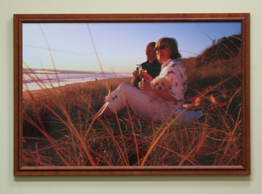 South Gippsland Shire Council
Photograph, Framed, Sandy and Terry with dog Jack at Venus Bay 2003, 2003
Framed and laminated colour photograph featuring couple Sandy and Terry with dog Jack. Drinking wine on beach at Venus Bay 2003. Photographed by Carolyn Jones. Brown wood frame with laminated surface. -
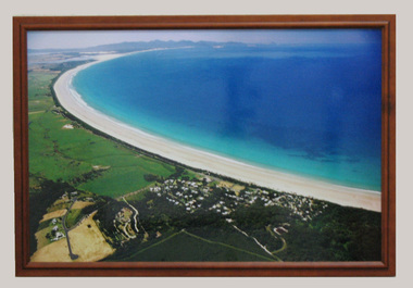 South Gippsland Shire Council
Photograph, Framed, 2003
... of Waratah Bay, the beach and Sandy Point . Wilsons Promontory can... an aerial view of Waratah Bay, the beach and Sandy Point . Wilsons ...Framed colour photograph featuring an aerial view of Waratah Bay, the beach and Sandy Point . Wilsons Promontory can be seen in the distance. -
City of Kingston
Photograph - Colour, 6 March 1993
Edithvale is a suburb in the City of Kingston. It is located between Aspendale and Chelsea on the Port Phillip Bay and built within remnant areas of the Carrum Carrum swamp. The foreshore precinct comprises a wide sandy beach, with low sand dunes and numerous historic boat sheds. The suburb consists of older style dwellings and former holiday houses, combined with mid-century housing and newer homes. The large blocks are increasingly subdivided and the existing dwellings demolished to accommodate units and townhouses, thus changing the landscape of the area and reducing the tree canopy.The beachside suburb of Edithvale was previously part of the extensive Carrum Carrum Swamp. The area was once a source of fish and eels for the Mayone-Bulluk clan of the Bunurong people. Over time the area was drained and predominantly devoted to dairy farming and holiday houses. The farms were gradually sold and subdivided with a large number of homes built after World War II and in the 1960s. Edithvale is mainly residential with a shopping strip along Nepean Highway but little significant industry was ever established in the area apart from a plaster works and confectionary factory, both now closed.Laminated aerial colour photograph of Edithvale as viewed from Alexandra Avenue in the north to Ella Grove Chelsea/Edithvale in the south. regents Park Aspendale can be seen in the top left. The area is built-up with residential housing and facilities including Edithvale Primary School, numerous churches and the Edithvale Railway station. Large sections depict the remnant Carrum Carrum swamp. Edithvale Common and the former "Duck Inn" (Melbourne Water/Friends of Edithvale Seaford Wetlands) can be seen. Edithvale Recreational reserve, the valodrome and Edithvale Public Golf Course are prominent. The image shows vacant land in the area now known as Aspendale Gardens and the newer residential section of Chelsea Heights is not developed. A bike path has been established to cover the secondary drain. The Golf Links Court residential development located off Hughes Avenue is a large vacant block.Black type on white adhesive label: 6-3-93 Black type on white adhesive label: 25/9211, 6/3/93, 11.20 am Black type on white adhesive label: 9211 Yellow circular adhesive sticker Black pencil: 9211 6-3-93 arrow pointing Nedthvale, carrum carrum swamp, aspendale, chelsea -
City of Kingston
Photograph - Colour, Circa 1993
Edithvale is a suburb in the City of Kingston. It is located between Aspendale and Chelsea on the Port Phillip Bay and built within remnant areas of the Carrum Carrum swamp. The foreshore precinct comprises a wide sandy beach, with low sand dunes and numerous historic boat sheds. The suburb consists of older style dwellings and former holiday houses, combined with mid-century housing and newer homes. The large blocks are increasingly subdivided and the existing dwellings demolished to accommodate units and townhouses, thus changing the landscape of the area and reducing the tree canopy.The beachside suburb of Edithvale was previously part of the extensive Carrum Carrum Swamp. The area was once a source of fish and eels for the Mayone-Bulluk clan of the Bunurong people. Over time the area was drained and predominantly devoted to dairy farming and holiday houses. The farms were gradually sold and subdivided with a large number of homes built after World War II and in the 1960s. Edithvale is mainly residential with a shopping strip along Nepean Highway but little significant industry was ever established in the area apart from a plaster works and confectionary factory, both now closed.Aerial colour photograph of Edithvale as viewed from Alexandra Avenue in the north to Ella Grove Chelsea/Edithvale in the south. The area is built-up with residential housing and facilities including Edithvale Primary School, numerous churches and the Edithvale Railway station. Large sections depict the remnant Carrum Carrum swamp. Edithvale Common and the former "Duck Inn" (Melbourne Water/Friends of Edithvale Seaford Wetlands) can be seen. Edithvale Recreational reserve, the valodrome and Edithvale Public Golf Course are prominent. The image shows vacant land in the area now known as Aspendale Gardens and the newer residential section of Chelsea Heights is not developed. A bike path has been established to cover the secondary drain. The Golf Links Court residential development located off Hughes Avenue is a large vacant block.Yellow circular adhesive sticker on plastic Black ink (marker): * (asterisk) Black type on white adhesive sticker: P000108edithvale, aspendale, chelsea, carrum carrum swamp